Motacilla flava
 Vulnerable
 Contributed:
| Habitats | Wetland Thickets, Wetlands with Shallow Banks |
|---|---|
| Presence In Israel | Summer, Migrant |
| Breeding In Israel | Breeder |
| Migration Types | Long Range |
| Zoographical Zones | Mediterranean |
| Landscape Types | Wetlands, Fresh Water, Marsh |
| Vegetation Types | Marsh and Riparian |
| Vegetation Densities | Medium, Low |
| Nest Locations | Ground, Wetland Thickets |
| Diet Types | Invertebrate |
| Foraging Grounds | Ground |
| Body Sizes | Small (up to 500g) |
| Threat Factors | Wetland Drainage & Pollution, Habitat loss and fragmentation |
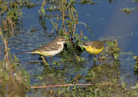
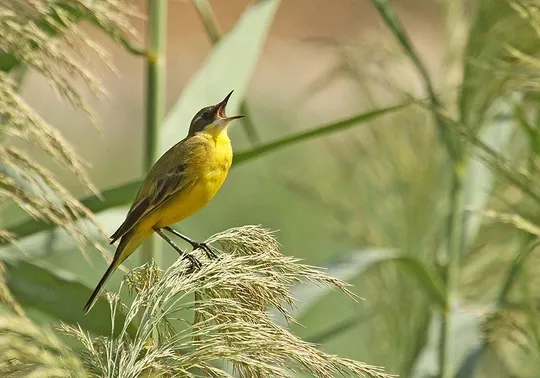
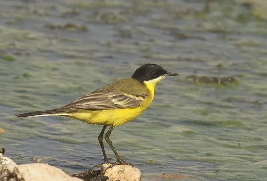
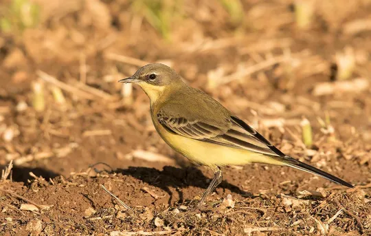
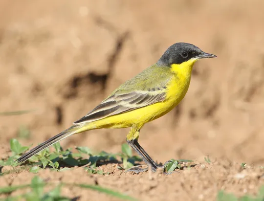
The Western Yellow Wagtail is a small delicate yellow-green-brown songbird, with a slender elongated body, a long tail and a thin bill it uses to catch small insects. The male has bright yellow underparts, a brown-green back and distinct head markings (that vary between the many subspecies) and the female is paler and more uniformly colored. It spends most of its time walking or running on the ground, which is where it finds most of its food. The subspecies breeding in Israel is M. f. feldegg.
The Western Yellow Wagtail is an extremely rare summer breeder in the Hula Valley, northern Sea of Galilee and the Jordan Valley. Breeding in most areas is sporadic and not continuous. It was first discovered nesting in Israel in 1951, when 8 pairs were seen in the Nahal Enan meadow in the Hula Valley (Zahavi 1957). The drainage of the Hula and other marshes had a negative impact on the wagtails. Some recuperation was recorded in the early 1980s, when the number of breeding pairs in the Hula Reserve reached 15 (Gorney 1983) and other pairs were seen in the summer in northern Sea of Galilee, the Bet She’an Valley, the Carmel Coast, the Sorek Valley and the Be’er Sheva Valley (Shirihai 1996). In recent years, the number of breeding pairs in the Hula decreased with an estimated 10 pairs currently breeding in Israel.
The Western Yellow Wagtail nests on streambanks with low grassy vegetation in Mediterranean climates. It nests in low thickets on the ground and at the edges of freshwater bodies. When migrating it stops at varied habitats, including irrigated fields, pastures and grassy patches in the desert.
No specific conservation measures have been taken for this species to date.
The Western Yellow Wagtail should be studied and monitored – a survey of potential nesting sites should be conducted to obtain a more accurate assessment of the population and the factors affecting it. Habitats should be rehabilitated and wetlands in the Hula and Bet Tsayda valleys and other similar sites should be preserved and rehabilitated.
- פז, ע. 1986. עופות. מתוך אלון, ע. (עורך), החי והצומח של ארץ ישראל. כרך 6. הוצאת משרד הביטחון, ישראל.
- Shirihai, H., 1996. The Birds of Israel. Academic Press, London.
- Symes, A. 2013. Species generation lengths. Unpublished, BirdLife International.
- Species page at Birdlife International
Contributed:
Current Occupancy Map
| Data Missing | Sporadic | Limited Sites | Low Density | High Density |
|---|---|---|---|---|
| 0 | 0 | 0 | 0 | 0 |
Distribution maps
The maps presented here provide visual information on the distribution of species in Israel from the past and present, and the changes in occupancy and breeding density during the comparison period. For further reading
Relative Abundance 2010-2020
Breeding density values in the current decade as determined from experts' opinion and observations from databases.
| Data Missing | Sporadic | Limited Sites | Low Density | High Density |
|---|---|---|---|---|
| 8 | 12 | 12 | 21 | 19 |
Relative Abundance 1980-1990
Density values based primarily on the book The Birds of Israel (Shirihai 1996).
| Data Missing | Sporadic | Limited Sites | Low Density | High Density |
|---|---|---|---|---|
| 5 | 14 | 14 | 17 | 22 |
Occupancy 1990-2020
The map shows differences in the species breeding distribution between the 1980's breeding map and the current weighted breeding evaluation. Negative value - species previously bred in the grid and is not presently breeding; positive value - species has not previously bred in the grid and is currently breeding.
| Data Missing | No Change | Occupancy Increase | Occupancy Decrease |
|---|---|---|---|
| 6 | 35 | 1 | 9 |
Change in Relative Abundance 1990-2020
The map shows the changes in the relative abundance of a species in each of the distribution grids between the breeding map of the 1980s and the weighted current breeding evaluation. Negative values - decline in abundance; positive values - increase in abundance; zero - no change in abundance.
| 80 to 100 | 50 | 20 to 30 | No Change | 30- to 20- | 50- | 100- to 80- | Data Missing |
|---|---|---|---|---|---|---|---|
| 0 | 4 | 2 | 22 | 12 | 14 | 11 | 16 |
| Rarity | |
|---|---|
| Vulnerability | |
| Attractiveness | |
| Endemism | |
| Red number | |
| Peripherality | |
| IUCN category | |
| Threat Definition according to the red book |


