Melanocorypha bimaculata
 Regionally Extinct

 Contributed:
| Habitats | Mediterranean Batha, Mountainous Terrain |
|---|---|
| Presence In Israel | Summer |
| Breeding In Israel | Bred in the past |
| Migration Types | Long Range |
| Zoographical Zones | Irano-Turanian |
| Landscape Types | Mountainous |
| Vegetation Types | Steppe, Herbaceous |
| Vegetation Densities | Low |
| Nest Locations | Ground |
| Diet Types | Herbivore |
| Foraging Grounds | Ground |
| Body Sizes | Small (up to 500g) |
| Threat Factors | Tree planting, Habitat loss and fragmentation |
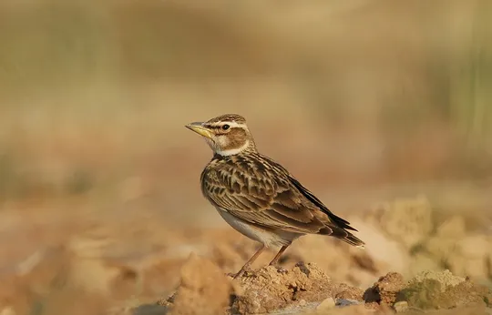
The Bimaculated Lark is a relatively large, stocky lark, with long wings and a short tail. A bit smaller and delicate than the Calandra Lark, distinguished by its more pronounced head pattern, the absence of a white trailing edge on the wing and the pale tail feather tips. Flight call is hoarse and harsh.
The Bimaculated Lark bred in the northern Golan Heights in a few scattered colonies until the late 1980s. About 50 pairs nested southwest of Majdal Shams, on Mt. Keta, Mt. Kramim and Mt. Hermonit (Shirihai 1996). During the 1990s, the number of birds decreased sharply due to habitat destruction resulting from the expansion of orchards and stone and tuff quarries. Towards the end of the decade, only a few pairs remained (Mayrose & Alon 2001). Since the early 2000s, no nesting activity of Bimaculated Larks has been observed in the northern Golan Heights. The Golan Heights population was a summer breeding population. Today the species migrates through Israel, is more common in spring, and is a rare winter visitor in the Arava.
The Bimaculated Lark nested on mountains at altitudes above 1,000 meters in the northern Golan Heights in patches of low native shrubland.
Habitat destruction due to expansion of settlements, deciduous orchard plantings, and tuff and sandstone quarrying, which significantly reduced suitable nesting habitats for Bimaculated Larks in the northern Golan Heights.
The Bimaculated Lark bred on the Mt. Hermon slopes and on mountaintops in the northern Golan Heights until the early 2000s. Its disappearance is probably due to habitat loss (montane herbaceous shrubland) because of agricultural planting and tuff and sandstone quarrying; however, they may be experiencing habitat loss also on their wintering grounds in Africa. There is a probability of the species returning to breed in Israel naturally, depending on the availability of suitable habitats.
- ישראלי, נ. ופרלמן, י. 2013. סיכום סקר עופות מקננים בחרמון. דו"ח מרכז הצפרות של החברה להגנת הטבע.
- פז, ע. 1986. עופות. מתוך אלון, ע. (עורך), החי והצומח של ארץ ישראל. כרך 6. הוצאת משרד הביטחון, ישראל.
- Shirihai, H., 1996. The Birds of Israel. Academic Press, London.
- Symes, A. 2013. Species generation lengths. Unpublished, BirdLife International.
- Species page at Birdlife International
Contributed:
Current Occupancy Map
| Data Missing | Sporadic | Limited Sites | Low Density | High Density |
|---|---|---|---|---|
| 0 | 0 | 0 | 0 | 0 |
Distribution maps
The maps presented here provide visual information on the distribution of species in Israel from the past and present, and the changes in occupancy and breeding density during the comparison period. For further reading
Relative Abundance 2010-2020
Breeding density values in the current decade as determined from experts' opinion and observations from databases.
| Data Missing | Sporadic | Limited Sites | Low Density | High Density |
|---|---|---|---|---|
| 8 | 12 | 12 | 21 | 19 |
Relative Abundance 1980-1990
Density values based primarily on the book The Birds of Israel (Shirihai 1996).
| Data Missing | Sporadic | Limited Sites | Low Density | High Density |
|---|---|---|---|---|
| 5 | 14 | 14 | 17 | 22 |
Occupancy 1990-2020
The map shows differences in the species breeding distribution between the 1980's breeding map and the current weighted breeding evaluation. Negative value - species previously bred in the grid and is not presently breeding; positive value - species has not previously bred in the grid and is currently breeding.
| Data Missing | No Change | Occupancy Increase | Occupancy Decrease |
|---|---|---|---|
| 6 | 35 | 1 | 9 |
Change in Relative Abundance 1990-2020
The map shows the changes in the relative abundance of a species in each of the distribution grids between the breeding map of the 1980s and the weighted current breeding evaluation. Negative values - decline in abundance; positive values - increase in abundance; zero - no change in abundance.
| 80 to 100 | 50 | 20 to 30 | No Change | 30- to 20- | 50- | 100- to 80- | Data Missing |
|---|---|---|---|---|---|---|---|
| 0 | 4 | 2 | 22 | 12 | 14 | 11 | 16 |
| Rarity | |
|---|---|
| Vulnerability | |
| Attractiveness | |
| Endemism | |
| Red number | |
| Peripherality | |
| IUCN category | |
| Threat Definition according to the red book |


